
Harmony is dedicated to the observation and quantification of small-scale motion and deformation fields, primarily, at the air-sea interface (winds, waves, and surface currents), of the solid Earth (tectonic strain), and in the cryosphere (glacier flows and surface height changes).
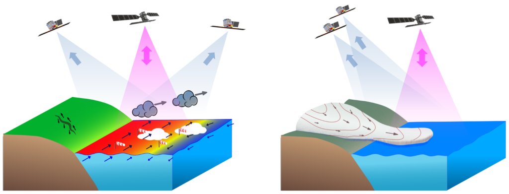
The retrieval of kilometre and sub-kilometre scale motion vectors requires concurrent observations of its components. This will be achieved by flying two relatively light-weight satellites as companions to a Sentinel-1 mission spacecraft, with a receive-only radar as main payload. The resulting line-of-sight diversity will be exploited in combination with repeat-pass SAR interferometry to estimate tiny deformation rates in the solid Earth, and for land ice processes. It will also be used in combination with Doppler estimation techniques for the retrieval of instantaneous ocean and sea ice surface velocities. Over oceans, geometry-diverse measurements of the radar backscatter will further allow the retrieval of surface (wind) stress and wave-spectra. The Harmony spacecraft will also carry a multi-beam thermal-infrared payload, which in the presence of clouds will allow the retrieval of height-resolved motion vectors. The combination of surface currents, surface wind-stress, along with TIR derived cloud-top height and cloud-top motion vectors will provide an unprecedented view of the MABL. In absence of clouds, the TIR payload will provide simultaneous observations of the sea surface thermal differences, providing a unique window to look at upper-ocean processes and air-sea interactions on the small ocean scales.
The formation flying architecture of Harmony enables the unique capability to reconfigure its flight formation so that instead of being optimised for the measurement of motion vectors, it is optimised for the measurement of time-series of surface topography. This will, among other outcomes, result in a globally consistent and highly resolved view of multi-annual glacier volume changes between well defined epochs, needed to better quantify the climatic response of glaciers. At the same time, Harmony will allow studying the seasonal and sub-seasonal processes from space that play a role in such responses, for instance by measuring variations in lateral ice flow and associated elevation changes simultaneously over large areas for the first time.